

The first stage of my Aspern-Essling set-up featured in
Post 60. This was just as much of the battlefield of
Aspern-Essling at a scale of 1:2,500 as I could put together
with my existing terrain tiles. Since then, I’d painted and
modelled a good quantity of terrain and figures. I
thought it was now time to bring the figures and the
terrain together on the tabletop. One way of doing this, I
thought, was by concentrating my efforts on completing
one tile at a time – finishing as much as possible of both
the terrain tile and the miniatures that would be
positioned on it. The plan was just to complete the
Essling side of the battlefield, an area of five tiles by five
(1m x 1m). I decided to make a start with the tiles at the
southern end of the battlefield.
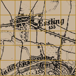
The Essling Grand Plan
Troop dispositions were to be based on the first day of
the battle, 21 May, as illustrated in the map of the battle
in Ian Castle’s Aspern & Wagram 1809 (see 1809
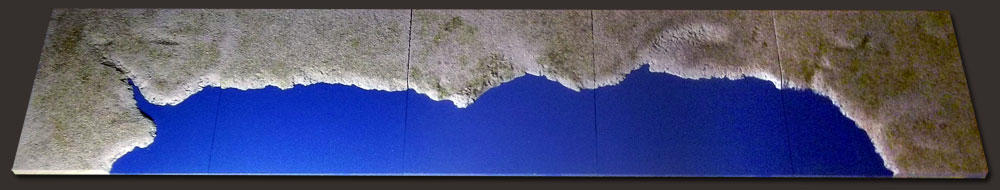
Reference). I began with five – what I called – coast tiles.
That’s to say tiles that could create watersides, whether
bank or shore of a lake, sea or wide river. These were
already made. They would represent the Stadtler Arm of
the Danube south of the village of Essling. However, the
design of my existing tiles meant that the river didn’t
extend as far north as it should have. I meant to correct
this by making sure that an area of scrub classed as bad-
going lined the riverbank where the river was at its most
northerly. The Stadtler Arm was 130m wide at the
crossing point from Lobau Island to the Mühlau salient –
at 1:2,500 60mm wide. Further downstream, the channel
widened enough to accommodate a number of
significant islets. I needed to model a few of these.


POST 145
145